This morning, we walked across the
roundabout to the Airborne Museum. The first building had lots of
info on uniforms and paratrooper gear plus a glider that was used to
carry additional troops and supplies.
Many of the gliders crash
landed among buildings, hedgerows and fields staked by the enemy to
foil landings. This was not the first time we heard about the
difficulties that the hedgerows caused the Allies. Not only are
these hedgerows dense and tall, they are everywhere between fields
and homes. They impeded the flow of men and supplies, but most
importantly, they provided cover to the enemy, making it more like
guerilla warefare, which was not something our forces were trained in
at that time.
The first building was pretty standard
museum stuff – cases with artifacts, etc. When we got to the
second building, things changed dramatically. They had a plane
replica with paratroopers sitting in it waiting to jump. As we
walked through it in the dim lights, we could hear the pilots static
radio, the constant noise of the plane engines and we could feel the
vibration of the plane in the air. Then as we got to the back, we
were suddenly confronted with an open door, a whoosh of air and the
feeling you just jumped into the night sky over Normandy as we walked
out onto a clear platform. Below us were the many parachutes of
other jumpers, the fields of Normandy and the rooftops of the town.
A truly incredible experience.
Next, we watched two excellent films
about the invasion and learned about the invasion from the
perspective of the airborne divisions.
 |
| An excellent map from the museum that shows the D-Day invasion of ground and air forces |
 |
| The church steeple where the paratrooper hung for hours playing "dead" Tacky replication of paratrooper and his chute and I debated whether to take this photo, but the church is authentic |
After leaving the museum, we
walked across the square to see the church where the paratrooper was
caught on the steeple and had to play dead for hours, hoping the
Germans below would not shoot. One of the best D-Day invasion
museums we have seen.
 |
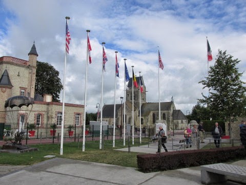
| I believe these are flags from the homelands of the paratroopers - note the SC flat with palm tree and moon way on the left |
We returned to the RV and stopped at a
grocery store a few miles away.
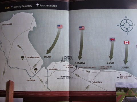
We are leaving the northern coast of France. This map will show a bit of where we have been, a photo of a map in one of our brochures.
We drove 1 ½ hours southwest across the peninsula to Mont St. Michel – a city built around an abbey on an island in the bay. We are staying right in the RV parking lot for its convenience to the Mont, although the RV lot is the last one in a very long series of parking lots. We are about ½ mile walk from the shuttle buses that take visitors across a causeway to the island.
 |
| View of the countryside |
We drove 1 ½ hours southwest across the peninsula to Mont St. Michel – a city built around an abbey on an island in the bay. We are staying right in the RV parking lot for its convenience to the Mont, although the RV lot is the last one in a very long series of parking lots. We are about ½ mile walk from the shuttle buses that take visitors across a causeway to the island.
After a late nap, we walked to the
information booth by the shuttle buses and found that the abbey
closed at 7pm. We decided it was too late to start our visit and
decided to wait until the morning to explore the abbey, surrounding
buildings and the narrow cobblestone streets that make up the town
that grey around the abbey.


No comments:
Post a Comment