Here is an overview map of our 2013 RV Trip. The green line is our westbound route and the brown line is the eastbound. I cannot figure out how to resize this map in the new Google Maps so that the legend does not cover the map, so if you are interested in the map, click on this link to view it in google where you can adjust the size yourself.
https://mapsengine.google.com/map/edit?mid=z4cbbhwdAtE0.krI0-OeHotJg
On our return from the Canadian Rockies, we stopped to see friends and family in:
Salt Lake City, Utah,
Longmont Colorado,
Des Moines, Iowa
Elmira, New York
New Jersey
Wilmington, Delaware
We hope you enjoyed seeing and hearing about our journey on this blog and we would be interested in suggestions for our 2014 adventure. You can write us with your suggestions by clicking on the "Post a Comment" at the bottom of the page.
We drove more than 12,000 miles over 3 months. We feel very fortunate that we were able to see the beautiful Canadian Rockies and Victoria and so much of these incredible United States, but it is so nice to be home!
August 2 and 3, 2013: Fairmont Hot Springs, BC to Challis, ID via Missoula, MT
Gloomy weather, chilly and raining. We got on the road heading south on Route 93, leaving the dramatic Rockies behind and driving through a pretty valley. We crossed the border after waiting in line about 20 minutes with no inspections or issues.
We continued driving on US 93 south through the ski resort town of Whitefish, MT and Kalispell, the only decent sized town in this part of the world. The road was scenic south of Kalispell as we drove along the huge Flathead Lake, but things changed as we drove through an Indian Reservations with folks living in derelict mobile homes and broken down campers.
We got a campsite just north of Missoula where the skies were starting to clear and the forecast is for clear skies tomorrow.
Saturday morning we had a nice pancake and sausage breakfast and I did the laundry. Afterwards, we headed into Missoula to run some errands and hit McDonald's for my monthly (approx.) Big Mac fix.

 The owner of the campground said there were three large fires in the area and the closest and largest one, The Lodgepole Fire, had 400 firefights working to contain it and expected this to continue til November.
Walked into town to grab and pizza and Jack got to enjoy USA major network news.
We continued driving on US 93 south through the ski resort town of Whitefish, MT and Kalispell, the only decent sized town in this part of the world. The road was scenic south of Kalispell as we drove along the huge Flathead Lake, but things changed as we drove through an Indian Reservations with folks living in derelict mobile homes and broken down campers.
We got a campsite just north of Missoula where the skies were starting to clear and the forecast is for clear skies tomorrow.
Saturday morning we had a nice pancake and sausage breakfast and I did the laundry. Afterwards, we headed into Missoula to run some errands and hit McDonald's for my monthly (approx.) Big Mac fix.

Then we continued south on route 93 along the Bitterroot River and over the 7,000 foot Lost Trail Pass into Idaho, the same route that Lewis and Clark used to head north after discovering that the Snake River would not get them to the Pacific. We drove through the ski resort town of Salmon and an hour south, stopped in Challis for the night. The scenery was impressive, but everything was hazy due to smoke from fires in the area as we drove along the Salmon River bordered by rocky cliffs.
 |
| How did they get that flag up there? |

 |
| Smoke, not clouds as seen from the RV Park. |
Walked into town to grab and pizza and Jack got to enjoy USA major network news.
August 1, 2013: Banff to Fairmont Hot Springs via Kootenay National Park
We woke to threatening skies and a cool morning in the high 50's--much better than yesterday when we woke to temps in the 30's and no electricity to run the fan on the furnace.
We stopped at a Canadian Tire, a large chain store that carries that strangest mix of merchandise. Tires, of course, and other automotive stuff, but also a large garden center, lots of kitchen stuff, including some nice high-end kitchen appliances along with picnic stuff, camping gear and even an small assortment of clothing. Anyway.....we wanted to get a battery meter to check our batteries and the salesman was an expert in deep cycle batteries that RVs and boats use and we learned a lot, so hopefully we will not have to experience dead batteries again.
 We eventually got on the road making the short trip from Canmore to Banff to explore the town and the Banff Springs Hotel. It is more like a castle and one of the early hotels built to attract tourists on the new trains that were crisscrossing Canada (same thing in America with historic lodges at Yellowstone, the Grand Canyon, etc.) We walked through the shops and checked out the terraces overlooking the valley, ringed by mountains and imagined ourselves to be one of those folks in the 20's who arrived with a letter of credit for $50,000 to spend the season. Today you can get a bargain package of one night hotel stay plus one round of afternoon golf for $499 each. Guess I need to start thinking about the lottery again.
 As we looked around Banff, mainly just a tourist town with lots of shops and restaurants, we saw a pretty little chapel. Next to the door was the services information about topic, times, etc. What was really interesting is at the bottom, they had an scancode for smart phones and tablets (you can see it if you can blow up the photo). Hmmm, anyone have any idea why?
 Leaving Banff, we drove north on the Bowman Parkway from Banff north to our Route 93 turnoff to head west over the Rockies Continental Divide to Kootenay National Park. The Parkway is supposed to be good for wildlife viewing; in fact, it is closed at night to protect the animals. We did get to see a couple of huge bull elk, but traveling mid-day is not a good time because most creatures are napping.
I was hoping to make a couple of stops in Kootenay, but it was raining and the low hanging clouds obscured our views of the mountains, so we continued through the park to Fairmont Hot Springs to our campground for the night - with electricity.
We stopped at a Canadian Tire, a large chain store that carries that strangest mix of merchandise. Tires, of course, and other automotive stuff, but also a large garden center, lots of kitchen stuff, including some nice high-end kitchen appliances along with picnic stuff, camping gear and even an small assortment of clothing. Anyway.....we wanted to get a battery meter to check our batteries and the salesman was an expert in deep cycle batteries that RVs and boats use and we learned a lot, so hopefully we will not have to experience dead batteries again.


I was hoping to make a couple of stops in Kootenay, but it was raining and the low hanging clouds obscured our views of the mountains, so we continued through the park to Fairmont Hot Springs to our campground for the night - with electricity.
July 31, 2013: Icefields Parkway to Canmore, AB
Still worried about the batteries, we decided to try to get a campsite a few miles away in Lake Louise where there are electric sites so we could recharge the batteries. The electric sites are usually reserved months in advance, but we wanted to try anyway. We stopped at the check-in, and they said they expected four sites to open up and to return in a half hour.
 We drove a few miles up to Lake Louise, one of the postcard places that IS the Canadian Rockies for many people. The place was mobbed with folks, many from the multitude of bus tours trying to capture the morning sun on the mountain behind the lake. We had been here before and the crowds were oppressive, so we did a short stroll around the base of the lake, took a couple of photos and returned to the campground to see if a spot had opened. No luck. He said return in another half hour. We drove down to the tiny shopping center, walked around a bit and returned to the check in. Still nothing and return in 15 minutes. We simply turned around and got at the back of the line of RVs waiting to check in. Again, nothing. Did it again, but nothing available yet, but the ranger was going out to do a spot check to see if there were any open sites. Jack had enough, so we decided to drive south about an hour out of the park to get a site at a commercial campground in Canmore.
We relaxed in the campground, letting the batteries recharge. Late in the afternoon, we did some grocery shopping in the downtown and back to the campground for the evening.

We relaxed in the campground, letting the batteries recharge. Late in the afternoon, we did some grocery shopping in the downtown and back to the campground for the evening.
July 30, 2013: Icefields Parkway


 |
| Mt. Edith Cavell |

 |
| Base of Angel Glacier with mini-icebergs |


We did another short, extremely steep hike to Emerald Lake with the most beautiful color water I have ever seen.


We saw three black bears and got a photo of one, but missed the shot of a bear and her cub.

 |
| Columbia Icefield. The size of cars and people walking on the path illustrate the immense size of the glacier. |
Next stop was the Columbia Icefield glacier for a quick photo. We did not make the steep walk up to the glacier or take the specialized icebus ride ON the glacier because we had done it last time we were here.


Just as we were getting ready for bed, we couldn't get the water pump to work because the deep cycle batteries died with no warning. Our panel just an hour earlier said the batteries were fully charged.
A sleepless night worrying that the refrigerator would quit or that the temps would go below freezing, jeopardizing the plumbing with no way to get any heat without battery power.
July 29, 2013: Jasper, AB
It got down into the low 40's last night and the clouds are breaking up with small bits of blue sky peaking through. We turned on the furnace when we got up and had a nice omelet breakfast.

We headed back west into the heart of Jasper National Park and stopped at Maligne Canyon and Maligne Lake, a beautiful glacier lake surrounded by mountains.

Maligne Canyon is a series of narrow crevices with the beautiful blue/green water roaring through.

The one-way drive to Maligne Lake is known for wildlife, but all we saw were a couple of deer.

We started a short walk around the Lake, but Jack was extremely tired, so we cut it short and returned to the RV for a nap.
We returned to the Jasper area to get a campsite and relax for the afternoon. We do have phone service as we were close to Jasper, but no internet, TV or electricity.
 |
| Clearing skies |
 |
| View while driving |

 |
| Maligne Lake |

Maligne Canyon is a series of narrow crevices with the beautiful blue/green water roaring through.

The one-way drive to Maligne Lake is known for wildlife, but all we saw were a couple of deer.

We started a short walk around the Lake, but Jack was extremely tired, so we cut it short and returned to the RV for a nap.
We returned to the Jasper area to get a campsite and relax for the afternoon. We do have phone service as we were close to Jasper, but no internet, TV or electricity.
July 28, 2013: Valmount, BC to Jasper, AB
 |
| View from the "Dining Room". Note my African Violet, hybridized by my grandfather and named for my dauther, Tina. It has survived the bouncing journey quite well lodged in a tissue box. |
We drove east on the Yellowhead Highway to Jasper, stopping for lunch at a pullout overlooking a fast moving creek.
 |
| Threatening skies hide the larger mountains |
Jasper is a nice small resort town in Jasper National Park in the northern Canadian Rockies.

 For the first time in many, many weeks, we ran into rain. Skies are overcast and sprinkling off and on, not good weather for appreciating mountain scenery.
 So, we (this "we" means me) washed clothes at a laundromat in town and walked around downtown Jasper, checking out the shops.
We drove east to the northeast corner of the park where we stopped to register for a campsite, then drove a little further to Milliete Hot Springs for a dip in the 104 degree mineral pool.
The scenery was spectacular, but it was strange to be in our bathing suits in the hot, steaming pool with lifeguards standing around dressed in parkas, ski hats and goves. Great relaxing way to end a chilly, nasty day.
We returned to the RV for a light dinner. With no electricity, internet or phone, we played some cards and went to sleep early.
July 27, 2013: Cache Creek, BC to Valmount, BC


 |
| Forest fire |
It was a pretty drive starting with dry arid hills and climbing into the lush green hills of the Canadian Rockies foothills.
We continued north on scenic route 5 to Valmount, a small town that serves as the eastern gateway to Jasper National Park.

July 26, 2013: Whistler, BC To Cache Creek, BC Via the Sea to Sky Highway
Poor internet this morning so my plans to finish updating the blog are kaput. Very frustrating.
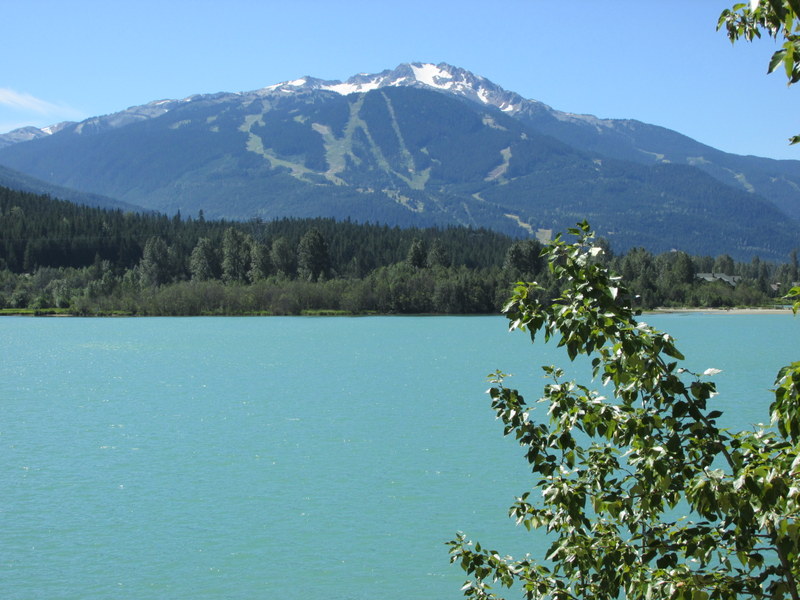
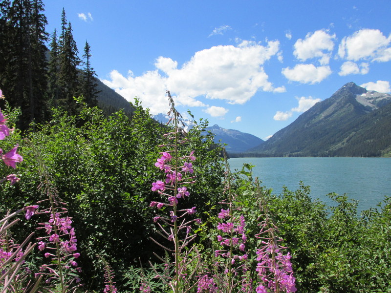
We continued north on the Sea to Sky Highway. OK, I know I have said many of our previous scenic drives were the best, but this time I really mean it. Pictures tell the story...

We stopped for lunch at a Provincial Park and took a short walk to a glacial blue-green lake surrounded by snow-capped mountains.
 The majestic mountain and lake views continued on this drive until the small town of Lilliooet where evergreen forests were replaced by sagebrush and rocky outcroppings, gradually giving over to dry rangelands and we eventually got to a real town called Cache Creek where we got a campsite for the night -- with WiFi that works!!!!


Jack planned a delicious steak dinner to celebrate my birthday. A fabulous day.
We continued north on the Sea to Sky Highway. OK, I know I have said many of our previous scenic drives were the best, but this time I really mean it. Pictures tell the story...
 |
| Our lunch stop walk to the lake |
 |
| Glacier closeup - blue tint indicates glacier rather than just snowpack |
 |
| Jack strutting his new Tilly hat. |
We stopped for lunch at a Provincial Park and took a short walk to a glacial blue-green lake surrounded by snow-capped mountains.


Jack planned a delicious steak dinner to celebrate my birthday. A fabulous day.
July 25, 2013: Vancouver Island to Whistler, BC
 |
| They block the wheels on last vehicle, even though those heavy doors behind us should keep us from rolling off... |


We returned to the campground for a nice turkey dinner and a little internet time, but the WiFi was not dependable and I didn't get to update the blog. Sat outside enjoying the scenic mountain vista from our campsite.
Subscribe to:
Posts (Atom)