Friday in Seward
 |
| View from our front window at our site in Seward |
We are still parked right on the water
in Seward with light rain all night and the clouds blocking out the
mountains across the Bay. The rain must be keeping down the number
of charter fishing boats going out, but there is a mid-size cruise
ship in port.
After lunch, welcome blue breaks in the
sky began to appear and even an occasional ray of sun. We walked
along the Bay down to a wonderful restaurant on the small boat
harbor. The locally caught salmon and halibut was fabulous.
Walking along the harbor, we watched the guys speed clean and fillet
the salmon and halibut that was caught on the fishing charters, then
they package it up and ship it home for the folks. A great dinner
and the weather is better – a good day.
 |
| Those few rays finally did lead to some blue skies |
Saturday in Seward
We woke to mostly cloudy skies, but no
rain and there were lots of boats heading out this morning, but today
being Saturday, it looked like a lot of the boats were personal
fishing boats. We checked out the local downtown that is known for
its small-town homey feel with many murals.
 |
| Early morning |
 |
| Cruise ship in port |
 |
| Downtown Seward |
 |
| Seward's Unique library |
We stopped at the library for their WiFi - an interesting building...
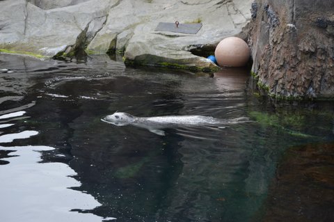
We went to the Sea Life
Center Aquarium. It was a modern, great facility – the displays
were wonderful and the variety of sea life was broad. The tanks were
not as large as the Charleston Aquarium, but we thoroughly enjoyed
it, especially the seals and the puffins.
We then drove the dirt road heading
south of Seward to Lowell Point.
 |
| Small waterfall on Lowell Point Road |
First we stopped at a State Park
where I did a nice 4 mile hike through the boreal forest to a point
where a river enters Destruction Bay. I saw two bald eagles and I grabbed my nice new telephoto lens, only to find I had no camera. Duh,
duh, duh. The stream was loaded with salmon going upstream to spawn.
Lots of raspberries along the trail and salmon in the stream---I
talked a lot to all the bears that may have been watching and carried
my bear spray right in my hand instead of a holster....
Returning from Lowell Point, we spotted a few houses that looked to be vacation homes that had really unique shingle siding.

Driving back from the point along the
bay, we spotted an otter in the water. He wasn't moving at all, but
drifting on his back – obviously taking a much-needed nap. Another
couple came up and used a unique way to get close-up photos from
above – a drone!
Great day.
Sunday, Seward to Cooper Landing
We woke to mostly sunny skies. Watched
the boats heading out in droves and another cruise ship is in port.
We packed up the RV, and drove to Exit Glacier. We took a short walk
to a view of the glacier, and I tried to hike across the outwash to
get to the toe of the glacier, but the river was running too strong
to cross it and had to abandon getting right up close to the glacier.
 |
| Closeup of the glacier ice |
We next stopped at a salmon weir where we watched them jumping the
small falls upstream and then headed north on the Seward Highway. We
are returning north the same way we came, but now the weather is
great, so I was able to stop at many of the scenic viewpoints for
photos.
 |
| Lily pad Lake |
About 35 miles north, we took the
Sterling Highway west where we saw miles and miles of traffic heading
in the opposite direction. They were fishermen leaving the huge
salmon fishing areas back to Anchorage and beyond after a weekend of
fishing. Alaskans are allowed to dipnet salmon from mid-July to July
31 and can harvest 25 per household. They simply put these gigantic
nets in the water near the mouths of streams and the fish swim into
them! We stopped at a national forest campground with nice sites,
but no services and filled with fisherpeople. I doubt we would have
gotten a spot anywhere in the area had we been here on the weekend.
Monday: Cooper Landing to Sterling
 |
| One of the many lakes |
We drove through the Russian River
famous fishing area with fisherpeople everywhere – most in various
forms of RVs, but most were truck campers. We took a dirt road that
mostly parallels the Sterling Highway, but heads deeper into the
Kenai National Wildlife area. The road was the worst we have been on
with lots of washboard, but we found a small, shallow lake that was
perfect for our kayak. The temps were around 70, no wind –
perfect! I spent the afternoon enjoying a couple of tours around the
lake, along with a pair of trumpeter swans. We were lucky and got a
site at another national forest campground, again it was filled with
fisher people.
 |
| Another lake along this terrible dirt road |
 |
| Kayak Ready! |
Tuesday: Sterling to Captain Cook
State Park
Our original plan was to spend a day or
so roaming around the close-by towns of Kenai and Soldotna, so we
called ahead for a campground, but there were no spots available.
The Kenai river that runs through here is another impossibly popular
fishing river when the salmon are running. So, we decided to head
north on a side road up west side of the Kenai peninsula to Captain Cook State Park.
We stopped at a wood carving place with
a great sense of humor.
We then headed north on the Kenai Spur
road to the end of the road at Captain Cook Sate Park.
The park is on a bluff
overlooking the Cook Inlet and we got a nice site among waist high
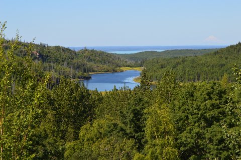
wildflowers (pink fireweed and white cow parsnip). I took a hike along the bluff at low tide with mudflats and rocks below and snow-covered mountains (active volcanoes in the “ring of fire” grouping) across the inlet. A beautiful, rugged coastline that reminded me of Oregon and Maine.
 |
| The cloudy skies are mostly hiding the snow covered mountains across Cook Inlet |
A pleasant, quiet night, but tomorrow
we NEED to find a campground with services as we need fresh water and
some electricity.
Wednesday: Captain Cook State Park south to Homer
Rain today and it is forecast to last
all day. We headed back south, stopped at the visitor center in
Kenai that had some fabulous displays about wildlife and native
Alaskans that have lived here since the “salt was added to the
sea.” The Russians were the first white men to inhabit this area
and the old town's Russian Orthodox Church and chapel were
picturesque.
We drove south on the west side of the Kenai Peninsula
to just north of Homer where we have a site with full hookups
overlooking the Inlet. Unfortunately, the sporadic rain and low
clouds are preventing us enjoying the views, but tomorrow is
forecast to be better and hoping to see more views like the one below.


