June 28, 2013: Deadwood to Bell Fourches, South Dakota


Nice fishing camp campground lst night with a stocked fishing hole.  You can catch and take home or they will cook it for you right there with all the dinner trimmings.  We had already planned dinner, so passed on fishing for our supper.

Woke up to another beautiful clear, cool morning.
We walked around downtown Deadwood (our second time here) without putting a single coin in a slot machine. 
Main Street, Deadwood
We did visit a local museum with exhibits of the gold rush that founded the town, the ethnic mix of the townsfolk and folk heroes like Wild Bill Hickok who was killed while playing poker at Saloon #10 and the legendary madams of the brothels that were operating openly into the early 1980's.

Actual door from brothel.  Lots of locks and a peephole.


Out of Deadwood, we took the beautiful Spearfish Canyon drive, stopping beside a small spillway for lunch and walking to see a dramatic waterfall. 
Our Lunch Spot in Spearfish Canyon


We stopped in the town of spearfish for shopping for supplies and food and stopped for the evening in a small town just north of I90 called Belle Fourches.  The campground has everything for at least 50 RVs plus tent sites, but there are only two of us here.  Hmm, we ran into this a week or so ago at another campground.  Is there something wrong?  Is it us?  Bet the Friday night trivia team is winning without us, too.....we are getting some kind of psycho-complex.

June 27, 2013: The Black Hills of South Dakota; Custer City to Deadwood Gulch

We called the recommended auto service guy down the street and he said to stop by at 10am.  He scanned the codes and it said a part that we had just repaired before leaving home was malfunctioning.
He cleared the code and the light and suggested that altitude could be playing games and not to worry unless the light returned.  So, off we went to explore downtown Custer City and bought the largest breakfast pecan roll I have ever seen.


Yup, that is a tunnel.  On the dash is the spec sheet with our exact width and height....
Side mirrors folded in so we could fit.
We then drove east into Custer State Park and up the famous scenic Needles Highway - a breathtakingly beautiful and scary drive up a narrow road with few guardrails up the mountains.  We had to fold in our mirrors to get through some of the tunnels and one tunnel we had to avoid altogether because we were too high.  Sure glad Jack was driving as I am not sure I could have done it. 


Needles Highway

Another scary tunnel


Sylvan Lake


We stopped at Sylvan Lake for lunch and a nap, then drove the scenic Iron Mountain Road with gorgeous views, including Mt. Rushmore. We had visited Mt. Rushmore on a previous trip, so this is as close as we will get on this venture. 


At one point, we had to stop for a herd of buffalo crossing the road.


The engine light has not returned.  We have a campsite just south of Deadwood for the night.

June 26, 2013: Hot Springs in the Black Hills, South Dakota

Beautiful cool morning with fluffy clouds against picture perfect blue sky.

We are playing the Southern Hills Course that has been rated #1 for multiple years in South Dakota.  It was gorgeous and in great condition, although the greens still had remnants of aerification.
The views were spectacular and some holes were uniquely designed with lots of elevation changes.  It had grown hot by the time we finished, but no humidity.


After golf we visited the Mammoth site a couple of miles away where they are currently excavating Columbian Mammoths which were almost twice the size and weight of the wooly mammoth.  The area had been a sink hole and the animals would slip in trying to eat the grass at the edges and couldn't get out because the sides were slippery shale.
  Over hundreds of years,the skeletons piled up and they have found 40 mammoths so far and expect many more than that.


We drove through the small town of Hot Springs with lots of old sandstone buildings.

 On the way out of town, our engine light came on.  Hmmm.  Checked the gas cap, turned it on and off a few times, but nothing changed.  The engine seemed to run fine, so we continued the 1/2 hour to our campground in Custer City, in the center of the Black Hills.  While checking in, the campground manager said he knew a guy who could put a scanner on it to determine the problem.  We decided to do that the next morning, but Jack called our service guy in Charleston and he said if the engine is running fine, it could just be altitude giving false readings.  Hot Springs and Custer City are over a mile high.

Cable and WiFi and full hookups tonight.  Yeah!

June 25, 2013: South Dakota-- Badlands to Black Hills

The plan for this morning was to get up early and get some sunrise photos.  But, I woke up at 4:30 am and it was already too light and the sky was cloudy was a big dark cloud to our north - just like yesterday.

We drove up to where you can do a few short hikes to a viewpoint that gives a window through the rock walls over the sculpted rocks spread out below.
The clouds were starting to move northeast, but we didn't have the patience to wait an hour or more just to get some pictures.  We wanted to get to the Black Hills and get settled for golf tomorrow morning.

We did take the westward scenic route and did manage to get some interesting photos at a few lookouts with clearing skies. 


We were originally going to take Hwy 44, a rural road west to the Black Hills, but Jack wanted to stop at Wall Drugs.  So we went up to I90 and made a quick tour (our second visit) of Wall Drugs and then headed west on I90 to Rapid City.  the winds from the north were fierce and I noticed one of our storage bay doors flapping open.  We pulled over and I closed and latched it, but as soon as I got going again, it flew open.  I woke Jack up from his nap, we pulled off at an exit and he worked for /2 hour trying to fix it by moving the latch mechanism so it would catch more securely.  Back on the road, and the bay door next to the previously broken one flew open.  We stopped twice more to relatch the second bay and finally got to Rapid City without tearing the bay doors off by their hinges.  As soon as we got off the interstate and changed our direction of travel (and the direction the wind was hitting the RV), both bays stayed closed and no more problems.  Those broadside wind gusts were just too much for the latching mechanisms.  We will have an RV repair place try to replace those mechanisms so we don't have to go through that again!

We got to the southern Black Hills region near Hot Springs to a campground near the golf course.  No TV here, but good internet so I updated the blog a few days.

June 24, 2013: Yangton to Badlands, South Dakota

It poured during the night and still looked threatening in the morning, so we decided to again postpone golf due to weather.  The woman in the South Dakota visitor center had recommended we play in Hot Springs in the southern Black Hills and that is where we are headed, so we made a tee time for Wednesday.

Today was a long day of driving.  We left our lakeside campsite and drove across Gavins Point Dam to the Nebraska side of the river to a bluff overlooking the Missouri River and the lakes.  We returned to the South Dakota side of the river and headed west on route 44 in southern South Dakota through rolling hills, corn fields and cattle grazing fields.  The lush plains grew drier the further west and this is where the two Indian reservations are (Red Bud and Pine Ridge).  The eastern Red Bud reservation had rich green farmland, but that quickly changed to more arid land with scattered groups of pre-fab homes and trailers.  They did have an attractive looking casino and hotel, but the parking lot was nearly empty.

We reached Interior, South Dakota, a very small town on the edge of the Pine Ridge reservation and the southern boundary of the Bad Lands.  We drove one mile down a dirt road in poor condition to a campground in my camping directory, but when we got there, it was gated and looked abandoned.  No wonder they had not returned my phone calls when I tried to make a reservation earlier in the day.
We then tried the campground right in Badlands National Park, but all the electric sites were taken, so back to Interior we went and got a site at a combination motel/campground that was fine. 


We were within a mile of the entrance to the Park, so we headed to the visitor center to view the exhibits and watch their 20 minute movie.  Then we drove up the north scenic route to an overlook, hoping to get some good photos with the dramatic looking stormy skies that were around us.  Unfortunately, the clouds never moved (isn't that against nature?) and the dark stormy skies made the sculpted rocks a drab gray.

We took a minute or two to ride around downtown Interior, home to 60+folks.  One home's front yard decorations caught our fancy.
 

We returned to the campground just as the wind picked up and what a wind it was!  The RV was faced into the wind and a building was in front of us, but still we were rockin and rollin.  No rain, though.  Nearby, a tent collapsed and the internal supports snapped, but that was the only damage we saw.  Apparently, these winds are not uncommon here.

 Jack was able to get only one tv channel (PBS) and no internet or phone service.  Spent the evening playing our version of 500 Rummy with jokers,and early to bed since our body clocks are still somewhere between eastern and central timezones and we are now in the mountain timezone.

June 23, 2013: Onawa, Iowa to Yangton, South Dakota

We got on the road about mid morning, crossing over the Missouri River to Nebraska and following it north along the Lewis and Clark scenic byway into Sioux City, Iowa.  Along the way, we drove through the town of Winnebago, and couldn't resist stopping for a photo.
We hopped on the interstate north so I could hit the South Dakota welcome center and stock up on pamphlets, primarily looking for info on South Dakota golf courses.

We got off the interstate in Vermilion and headed west, following the Missouri River again, which begins to run East-West here.
Just north of Yangton, we stopped at Spirit Mound.  It is a huge natural-made chalk hill in the middle of the prairie.  The Indians had told Lewis and Clark that 18" men lived there and would kill anyone with arrows who approached the hill.
Lewis and Clark hiked the four miles from the Missouri River to the hill to investigate.  They did not find the little men, but did have wonderful views of the surrounding prairie and they got their first glimpse of the massive herds of Buffalo that roamed the plains.  This is the only spot that is documented where Lewis and Clark both stood.  We hiked up the hill on a path through the thick prairie grasses, but we saw no little men or buffalo.

There is a 100 mile stretch along here that is a combination of national and state recreation areas where dams on the Missouri create lakes.  We scored a campsite right on the Lewis and Clark lake and were thinking of taking the kayak out, but it was very breezy and we were tired.  We made a tee time at the local municipal course for the next day.

June 21, 2013: Forest City, Iowa to Des Moines, Iowa

It thundered and rained hard during the night and was still pouring and black as night when we left the campsite to go to the service center.  Luckily we did not get any of the golf ball sized hail they were forecasting!  We were at the service center promptly at 7 am.  The technician came out and took it back to the shop and we waited.

At 10:30, the RV was finished, and we headed due south to Des Moines.  We got a campsite at the Iowa State Fairgrounds, only a few miles from the hospital where Jack's brother, Bill, is recuperating from intestinal surgery, similar to what Jack had.

After lunch, we drove to the hospital where Bill looked unbelievably well considering his major surgery.  He had no pain and he was already up and walking.  We ran some errands and returned to the hospital after dinner to visit with Bill again.  We were hoping to see Jack's nephew and family, but we missed them at the hospital.  We did get to see his neice and her four children (three of them triplets) who were bundles of energy and adorable.  Back to the RV before dark so we can back in and hook up the electric without flashlights.

June 20, 2013: Forest City, Iowa

Here we are in northern, Iowa with a map that shows our journey so far.  Each balloon can be clicked for more information about that location.


View SC to Iowa in a larger map


We moved the RV from their overnite sites to the service are at 6:45 am.  We were quickly joined for 4 or 5 more RVs, all of us waiting for the doors to open.  At precisely 7am, the lights were turned on, the doors opened, the coffee was already made and they had three people ready to sign us up for appointments. We filled out the paperwork and waited to see if they could squeeze us in today or whether we would have to wait til tomorrow.  Luckily, they took the RV right away, but didn't get to start work on it til later in the morning.  We spent the day in their comfortable waiting room, walking across the street to a lodge for lunch.  At 3pm, they brought out the RV with everything fixed but the steps, which needed a replacement part that be in the next morning.  Back to the their parking lot campsite for the evening, but it does have electric as it is 88 degrees with high humidity.

In case you are wondering, we could have made an advance appointment if we had called about month or more previously, but we didn't want to impose that requirement on our travel schedule.

June 22, 2013: Des Moines to Onawana, Iowa through Loess Hills

The low was 75 degrees with high humidity, so we ran the AC all nights.  Jeeze, we thought we were getting away from this Charleston-like weather!

Cloudy, warm and humid at 6am with the forecast for very hot and humid.  We had been thinking of golf, but decided to wait to get better weather.  We spent the morning doing some RV maintenance and cleaning. 
We followed him for a while until we could safely pass.
After lunch, we drove about 20 miles on I80 west to catch Iowa scenic route 44 west, going through some pretty hill country and enjoying some rural sights, eventually reaching the Loess (pronounced Luss) Hills area near the Nebraska border.

The Loess Hills are made of wind-blown silt and the only other place in the world this type of geological formation exists is in China.
As we approached the area, we saw the hilly farms were terraced, probably to avoid erosion.  Eventually, we learned from some roadside reader boards that the terraces were not man-made, but were the result of the natural erosion process of the silted hills.
They described the hills as pie crust like and we could see soft hills that were deeply terraced as well as sharp ridges.  We drove to an observation deck in the Pisgah forest on a dirt road where the ridge line was more pronounced.  Most of the area is either planted with corn or used as range land for livestock.  We learned that Iowa has the largest percentage of actively farmed land in the United States.  But in some protected areas, the native prairie grasses are encouraged.  There are over 300 different species of native grasses and wildflowers that make up the prairie and they grow so thick, tree seeds cannot get to the soil to germinate.

We spent the night in a small town on the Nebraska border which had a nice clean laundry room where I spent a couple hours.

June 19, 2013: La Grange, MO to Forest City, IA

The plan was to drive north in Missouri to Keokuk, cross back east over to Illinois and go up the exceptionally scenic stretch of The Great River Road to Nauvoo, but as soon as we crossed the River, there were detour signs.  Probably more flooding.  So we took an inland route north to Nauvoo, passing an interesting front yard with old gas tanks.
 

Nauvoo is where Joseph Smith and his Mormon followers fled Missouri after the governor signed an extermination order. The Mormons built the town here from 6,500 to 20,00 over a few years and ran it as a theocracy with their own courts, militia, schools, etc.  Non-Mormon neighbors became incensed when disagreements had to be heard in Mormon courts where they questioned the fairness of judgments and eventually violence erupted.   
There was also a schism in the LDS church beginning with Joseph Smith's adoption of polygamy and other issues.  The problems escalated and Joseph Smith and his brother were jailed in a nearby Illinois town where a mob assaulted the jail and lynched them.  Most of the inhabitants of Nauvoo followed Brigham Young west to Salt Lake City.  The LDS church as done massive restoration and reconstruction of the historic district as it was n the 1840's.  The original $1,000,000 temple was reconstructed exactly as the original in the same spot.  We took a horse drawn carriage ride to get an understanding of the story and the town.  We were impressed with the determination, courage and faith of the Nauvoo people.

We drove the rest of the day to northern Iowa to the Winnebago plant in Forest City to have a few things repaired.  They have electrical hookups, so we stayed right there and were in line at 7am when they opened to sign up for the earliest available service.  We were lucky to have them look at it the same morning and we spent the day in their comfortable waiting area, returning to the campground for the evening to await a part scheduled to arrive the next morning.

June 18, 2013: Bowling Green, MO to Hannibal, MO

Cool, dry and a crystal blue sky this Golf Day!

  A short drive north on The River Road, with some neat rural scenes and an occasional glimpse of the broad Mississippi, we arrived in Hannibal, boyhood home of Mark Twain.


We had visited here a few years ago and it was fun to drive around the small historic district and reminisce. 

After driving twenty minutes on dirt roads, we arrived at the public golf course, which looked surprisingly nice considering we were in the backwoods somewhere, only our GPS knew where..
The greens were in great condition, but the first nine holes were fairly new and a bit boring.  The back nine was older and had lots of trees (unfortunately for a few of Jack's drives) and personality. 

Have you noticed yet that I have not mentioned how we scored?  Unfortunately, the humidity began to build and by the time we finished at 3pm, thunderstorms were threatening.  Right during my backswing on #16, a series of three huge booms exploded.  At first, I thought it was the beginning of big thunderclap, but it was a lot louder and deeper.  When we returned to the clubhouse, Jack found it had been a sonic boom and its accompanying echoes, made by a jet. 

We stayed in a nice state park with a campsite on a small lake a half hour north of Hannibal in a small town called La Grange.  It is a pretty spot with cottonwood puffs drifting about and mama and papa geese strutting about with their little ones in tow. 

Score?  What score?

June 17, 2013 Pere Marquette State Park, IL to Granite City, IL to Bowling Green, MO

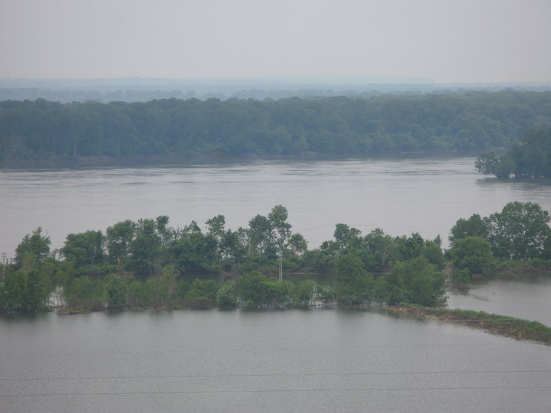
Yesterday, we drove through a gorgeous stretch of Mississippi riverfront, but did not stop at any of the small towns for photos because we wanted to get to the campground early enough to watch the Open.  Today, we returned south along The River to do some exploring.  Before we left Pere Marquette State Park, though, we drove a narrow scenic road in the Park to a number of lookouts on the top of the ridge.  Unfortunately, these viewpoints are only scenic in winter when the leaves are off the trees.  This is prime winter eagle viewing territory, so the overlooks are for bird-watching.  I did get one photo of the flooded, muddy river in the distance.


We stopped in the small town of Grafton with lots of restaurants, bars and a marina for the St. Louis weekend crowd, but it was deserted on this Monday morning, except for flood clean-up crews.
 
We could see high water marks on the sides of buildings and their road next to the river was gone. 
End of the road


Their entire ballfield was under water and a house sat in the middle of the river, with no way to get to it except by boat.  


The homes that did escape damage we on the tallest stilts I have ever seen.


 A little further south we came upon the quaint village of Elsah that was a real step back in time. This hamlet had been mostly cut off from the world until 1965 when the River Road was built. Beautiful stone cottages with amazing gardens, picture perfect churches and an old time school.


We continued southeast along the river near St. Louis to check out the Lewis and Clark historical site. It had a short film and exhibits about the team wintering here preparing for their amazing journey to the Pacific. 
Although they have an area where you can view the confluence of the Mighty Mississippi and the Missouri rivers, it was flooded, so we went a 1/2 mile up the road to the Confluence Tower. The tower gives a bird's eye view of the confluence as well as the incredible flooding. Friday night trivia buffs, listen up: The Missouri is longer than the Mississippi, runs faster and carries more silt. We were told that you can still see the Missouri waters more than a mile downstream from the confluence because of the different color due to the higher silt content.


The water to the first tree line is all flooded farm fields.  the Mississippi is on the right between the trees, while the Missouri is coming from the far right.

Confluence of Mississippi and Missouri


View from the top at the parking lot with our RV

We drove west on the interstate around St. Louis and stopped at a rest area to have some lunch.  We saw this is the dog walking area... !


His pooper scooper was a big bucket!
We drove north to Bowling Green, Missouri to a campground with guaranteed good internet service. Yeah!

While watching the news, we found that we must have been under a silver-lined cloud because much of the St. Louis area experienced drenching rains, flash floods and a lot of street flooding, but somehow all we saw was a little drizzle.  Planning a tourist day off tomorrow to play some golf in Hannibal,Missouri, home of Mark Twain.