June 26, Friday: Whitehorse
Checked email for the first time in
days and uploaded text and a portion of the photos before our
internet time ran out. We got out mid-morning under gray skies and
went to the visitor center for info, then walked a couple of blocks
to the MacBride Museum for an interesting historical exhibit of
Whitehorse. The Yukon Mounties were headquartered here in Whitehorse and the cabin was included in the museum along with the original telegraph office, and information about mining, railroads and river travel.
 |
| Extinct Short Faced Bear |
We returned to the RV for lunch, accessed the courtesy
visitor center WiFi from the parking lot. We decided to stay here
another night and checked out the two other possible campgrounds, but
found the place we stayed last night to be the best. The rain that
had started at lunchtime wound down, so we went to the Klondike
riverboat museum, but they remained closed because of the slippery decks. Instead, we went to the Beringia museum – excellent museum
abut the land bridge between Asia and North America.
One of the interesting things they did was meld the stories passed down for thousands of years of the First Nations Peoples with the science of these old extinct creatures. Some dealt with the creation of earth by the Crow....
 |
| The Crow |
We did a little grocery shopping, and
tried a steak and pizza place for dinner in oldtown Whitehorse.
Restaurant was very dark with leather banquettes ala old time steak
houses and the pizza was good. We returned to our campground for the night. Near the entrance, they have quite a few old US Army military vehicles used in the construction of the Alaska Highway.
June 27, Saturday: Whitehorse
Woke to a cold (40's) clear morning.
Put the furnace on and made coffee. We stopped to top off the tank
in Whitehorse, our last real city until we get to Alaska. Just past Whitehorse, we detoured off the Alaska Highway north up the Klondike Highway. This is a
paved road, in so-so condition with occasional bursts of
disintegrating highway that are bumpy, gravelly, and dusty.
The vegetation is much closer to the road here and the road is narrower and
sometimes there are no shoulders. Lake, spruce and aspen scenery with
occasional peaks at mountains with a bit of snow clinging to the
shadowy portions.
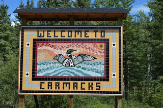
We arrived in Carmacks, expecting to walk a town historical tour, but it was just a
sad little town. We drove through and just snapped a few photographs of the old cabins
that were used when Carmacks was a stagecoach stop between Whitehorse and Dawson City.
 |
| This was the stable for the Stagecoach horses |
A few miles north of town, we
stopped at Five Finger Rapids that gave a view of the Yukon River
rapids far below. I made the hike down (200+ steps plus a one mile
walk) to the rapids that afforded some great views. The walk was
great – first through spruce forest, then aspens and back to spruce
before arriving at the river.
 |
| See that little white speck in the upper center from my viewpoint overlooking the rapids? The RV! |
 |
| The closest channel is supposed to be the safest navigation route through here. Many miners lost their lives trying to negotiate these rapids, often in homemade rafts. |
 |
| One set of stairs |
 |
| A second set of stairs |
I returned out of breath from climbing
all those steps and we drove a few more miles to a Territorial
campground on a creek. A great change from the crowded campgrounds
in Whitehorse.
June 28, Sunday Klondike Highway
Woke to another clear cold morning with
temps in the high 40s. Jack put the furnace on and we slept in a
little longer. I made a pancakes and sausage breakfast and we got on
the road about 9:30. While driving, I glimpsed a grizzly, but it was
on a curve of a road with no shoulders, so it was unsafe to stop, and
backup around the curve. Darn, our first grizzly sighting! I also
got to see a large female moose standing on a sandbar in the middle
of a wide river, but by the time we returned, she had disappeared
into the trees. This is desolate country with no towns, spotty road
conditions but some pretty scenery.
We made it to Dempster Corner
whose only claim to fame is it is the corner of Klondike Highway and
the Dempster Highway with one, unattended fuel station. We were
almost out of diesel, so we spent about 15 minutes figuring out how
the kiosk and pumps worked – not difficult, but very confusing at
first. We filled up and turned right onto the Dempster Highway.
My
original plan way back when doing my initial planning was to drive this dirt road 400 miles
north through Northwest Territories, above the Arctic Circle to the
end at Inuvit on the MacKenzie Delta. I had to abandon that as they
talked about the prevalence of flat tires due to the shale surface
and even though we carry a spare, the recommendation was for two
spares plus we would not be able to change the rear tires by
ourselves anyway. The nearest town could be more than 150 miles
away.... so, we decided to just drive the 45 miles up to the
Tombstone Territorial Park. Dirt road with stupendous mountain scenery.
A gorgeous spot in a high valley
surrounded by mountains. We got a campground spot on the North Fork
of the Klondike River, and walked down to the visitor center for info
on hikes. Returned to the RV, Jack made a fire and we sat outside
until the building clouds decided to share their moisture.
 |
| Campsite in Tombstone Territorial Park |
June 29, Monday: Tombstone Territorial
Park to Dawson City
After my hike, we returned the 45 miles
south on the Dempster Highway to the Klondike, turning northwest for
the 25 miles to Dawson City. We got a campsite with electric, water
and sewer and enjoyed lengthy showers and charged up all our
computers, ipads and phones. I did laundry and made a late dinner.
I was really TIRED.


