We called about getting the ferry to Victoria from Port Angeles on stand-by, but they are booked solid due to a huge car show in Victoria. Now we know why we had seen so many antique cars on the road for the past week. Instead of waiting a day or two to get the ferry from here, we decided to drive to the Seattle area. Hopefully, we will get the ferry to Victoria from Vancouver.
On our way to Seattle, we stopped at the Naval Undersea Museum near Bremerton. It was an interesting look at submarines, diving gear, torpedoes and mines. AND we got to view our View in the parking lot through a submarine periscope in the recreated conning tower. A nice break from driving the 150 miles to Seattle.
We opted for the RV park closest to Seattle, across the lake in Bellevue, but first we wanted to reconnoiter (see how that military stuff seeps in?) downtown Seattle for parking which we heard was difficult. Yup, Thursday rush hour in downtown Seattle, and it was ugly. We spent an hour in stop and go traffic around the city so Jack could see the waterfront and the Space Needle and look for anywhere our RV could be parked. We did notice, however that drivers were mostly polite for city folk, and had a great time people watching while we sat in traffic. There is one of everything here - we especially liked the 6' hooker, dressed in thigh high boots and a mini-skirt that almost covered her behind, except it was a man.... since this is a G-rated blog, no photo, sorry.
It took more than a half hour to go the 11 miles to Bellevue to find our campground is just a parking lot next to Interstate 90 with only a few feet of space between RVs. Many are dilapidated and apparently folks living here full-time. We were so tired, the noisy interstate didn't even bother us.


July 17, 2013: Olympic Peninsula
We got off to a late morning start to explore the little town of Port Townsend on the northeastern tip of the Olympic Peninsula. Lots of old historic buildings from the late 1800's when this was a bustling timber port waiting for the promised railroad to come. It never came, and the town slept through most of the 20th century, when it was rediscovered by folks looking for a temperate, dry, small town. Now it is again a vibrant town of retirees, artists and tourists with lots of interesting shops and restaurants. We drove to the top of the bluff overlooking the city where the timber barons built palatial homes overlooking the Strait of Juan de Fuca.
 We returned west to the Port Angeles area to explore the Hurricane Ridge section of the Olympic National Park. The 17 mile drive in from Port Angeles to the heart of the Olympic National Park on Hurricane Ridge climbed to over a mile to a beautiful area with views of the Olympic Mountains, many still with snow.
 We saw black tailed deer when we hiked a 1 1/2 trail up to a ridgeline where a storyboard said we should enjoy 360 degree views of the mountains, Canada and the greater Seattle area.

The haze and the smog made it impossible to see much beyond the mountains.
Returning down the mountain, we saw a fawn and its mother alongside the road.

 On our way out of town to get a site at the same campground we had used two nights ago just east of Port Angeles, we noticed this:


The haze and the smog made it impossible to see much beyond the mountains.
Returning down the mountain, we saw a fawn and its mother alongside the road.


Fuel prices are not as bad as we expected (we use diesel). We have paid over $4.00 just twice since our trip began. Of course, Canada is yet to come.....
July 16, 2013: Olympic Peninsula
 Jack found a golf course a half hour away in Port Townsend at the northeastern tip of the Olympic Peninsula. The layout was nothing fancy with occasional glimpses of the bay beyond, but it was a beautiful day and it felt great to be out on the course. It helped that I shot one of my best 9's ever (we're not talking about what happened on the back nine).
 July 15, 2013: Olympic Peninsula


We continued north up the western coast of the Olympic Peninsula to the Hoh Rain Forest where we walked a one mile trail through the forest of giant Sitka Spruce, cedar and hemlocks where huge fallen logs provide nourishment for sprouting trees.


We followed route 101 around the peninsula to the northern coast and got a campsite in Port Angeles. The diesel prices are the same now that we are back into civilization, and surprisingly diesel is cheaper than regular gas and much less expensive than premium gas.
A great day from the beach to the rain forest.
July 14, 2013: Olympic Peninsula


We stopped at a small museum with lots of shells and marine creature skeletons, but it was quite a hodgepodge. They had huge sign outside that said free, but as soon as we entered, there was a hard sell for a $5 per person donation. I have no problem giving donations and I have no problem paying admission fees, but Jack and I both hate the false advertising of free, compounded with a used car salesman's hard sell line. They got no money from us.
We stopped at a bird refuge where snowy owls nest in winter - would love to see that!
We continued north to the next small town of Ocean City where we again drove on the beach, parked with our windows facing the ocean and had lunch and a nap to the sound of roaring surf.
It is chilly (only 60 degrees), windy and there is a light fog bank all along the shoreline.

We drove further north through a few more really tiny ocean towns before heading inland on route 101 to go around the Indian Reservation that has no thru roads.


We retreated into the warmth of the RV for a nice Italian dinner and an evening of competitive rummy. No electricity, water or dump, so we set the propane furnace on low to keep us comfortable overnight.
July 13, 2013: Olympic Peninsula
When we left the Mt. Rainer National Park campground yesterday, our panel showed the batteries were depleted and there wasn't enough power to run the water pump correctly. We had a Camping World look at it earlier in our trip, but we didn't trust their judgment that the batteries were fine, but the truck needed a new alternator. We had let it go because we had electric in most campgrounds and it was only a problem if we wanted to camp without it for more than one night. The owner of this campground used to have his own RV repair service, so we asked him to diagnose our problem. Turned out to be a bad cell in one of the batteries, but you cannot replace only one because the older battery will pull the new one down. He called a local guy who happened to be in on his day off and we ran over so he could put in the two new batteries. Relatively easy fix and a lot less expensive than we had paid for batteries in the past.
While doing laundry, I noticed a sign that one of the folks in the campground washed and waxed RVs. I had done it before we left and we had stopped at a couple of do-it-yourself places with the extra tall bays to get off the worst of the bugs and road grime, but it was in need of some spit and polish. They did it in a few hours for $100 - another great bargain, but an expensive day!
I made homemade red gravy (spaghetti sauce) with sausage and meatballs on our outdoor cook stove.
This maintenance day was good for Jack because he had hurt his foot and hopefully a day of rest will help it heal before we get to Olympic National Park where there will be a lot of walking.
While doing laundry, I noticed a sign that one of the folks in the campground washed and waxed RVs. I had done it before we left and we had stopped at a couple of do-it-yourself places with the extra tall bays to get off the worst of the bugs and road grime, but it was in need of some spit and polish. They did it in a few hours for $100 - another great bargain, but an expensive day!
I made homemade red gravy (spaghetti sauce) with sausage and meatballs on our outdoor cook stove.
This maintenance day was good for Jack because he had hurt his foot and hopefully a day of rest will help it heal before we get to Olympic National Park where there will be a lot of walking.
July 12, 2013: Mt. Rainier to The Olympic Peninsula
Up early to drive 1/2 hour from our campground to Sunrise Point, Unfortunately, the clouds obscured most of the mountain and even when we could see it, the snow-capped mountain blended with the grayish sky, so no photos.
We did capture one great picture of a mountain in the distance (Mt. Hood?) with a telescopic lens as its top was highlighted with a ray of sunshine breaking through the clouds.

We said goodbye to the majestic Mt. Rainer and drove southwest around Tacoma to the Olympic Peninsula to a small town called Hoquaim that is one of the entry towns to the northern Washington coast beach towns and Olympic National Park. We have a nice site overlooking the Hoquaim River.
We did capture one great picture of a mountain in the distance (Mt. Hood?) with a telescopic lens as its top was highlighted with a ray of sunshine breaking through the clouds.

We said goodbye to the majestic Mt. Rainer and drove southwest around Tacoma to the Olympic Peninsula to a small town called Hoquaim that is one of the entry towns to the northern Washington coast beach towns and Olympic National Park. We have a nice site overlooking the Hoquaim River.
July 11, 2013: Mt. Rainier
 |
| Her babies were safely in the brush by the side of the road |

At Paradise, we walked a couple of trails, but it was tough going in spots because of the snow and the elevation was about 4,000 feet.


We then walked across to another trailhead and Jack decided to take a rest while I hiked up to one of the many glaciers on Mt. Rainier.


The wildflowers were just beginning to bloom, so there were lots of white and yellow flowers, but the meadows covered in a profusion of wildflowers that we heard about were a few weeks away.

We drove south around the mountain to the east side of the park ad got a campsite in a National Park campground there at 5,000 feet. Another relaxing spot in the woods made for a great night's sleep.
July 10, 2013: Mt. St. Helens to Mt. Rainier
Woke to heavy, overcast skies and chilly temps. The clouds are the fog bank that rolls in off the Pacific and we are told it will clear later in the morning. We spent the morning doing housekeeping/maintenance and updating the blog.
We left the campground a little before noon, stopped for lunch and bank on Interstate 5 to the exit for Mt. Rainier. We caught occasional glimpses of both mt. St. Helens and Mt. Rainier from the Interstate. We drove through a couple of small art communities, one of which was an outdoor metal and driftwood sculpture garden and we had to stop to enjoy.


We drove to the southwestern Nisqually entrance, stopping for a few photos of Mt. Rainier, the tallest mountain in the Cascades at over 14,000 feet.

We got a site at the campground in the park, deep in the forest. A beautiful spot, but no electric or water. We had a big salad for dinner, made a campfire and sat outside til dark, enjoying the clean, fresh scent of pine trees and the luxurious quiet.

A few hands of cards and asleep by 11 with only one window open because it was expected to go down in the 40's.
We left the campground a little before noon, stopped for lunch and bank on Interstate 5 to the exit for Mt. Rainier. We caught occasional glimpses of both mt. St. Helens and Mt. Rainier from the Interstate. We drove through a couple of small art communities, one of which was an outdoor metal and driftwood sculpture garden and we had to stop to enjoy.


We drove to the southwestern Nisqually entrance, stopping for a few photos of Mt. Rainier, the tallest mountain in the Cascades at over 14,000 feet.
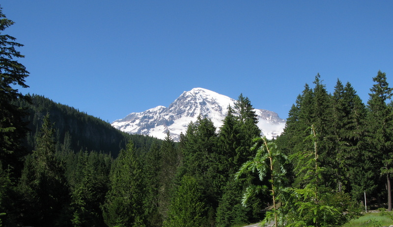
We got a site at the campground in the park, deep in the forest. A beautiful spot, but no electric or water. We had a big salad for dinner, made a campfire and sat outside til dark, enjoying the clean, fresh scent of pine trees and the luxurious quiet.

A few hands of cards and asleep by 11 with only one window open because it was expected to go down in the 40's.
July 9, 2013: Columbia River Gorge to Mt. St. Helens

The first was Horsetail Falls where we climbed a trail way above the waterfall to a second, smaller waterfall called Ponytail, allowing us to walk behind the Falls.


In this westerly portion of the Gorge, we traveled the original Oregon scenic Highway 30 built in 1916, a narrow twisting road high above the Columbia River through a rain forest. The average annual rainfall here is 75" and it declines 1" per mile as you travel East.

 |
| Tunnel on the original road, no longer used |
Our last stop along the Gorge was at the Vista House and overlook, a beautiful spot.
 |
| Vista House |
 |
| Mt. Hood, OR |

 |
| Mt. St. Helens |
 |
| Devastation still after 30 years |
 |
| Jack called the dead tree stumps graves of Mt. St. Helens |
 |
| Crater of Mt. St. Helens is slowly building a dome in the center |
 |
| One of many lakes formed when eruption debris dammed creeks |
 |
| This photo is NOT blurry. This is the way these hillsides look in person because of mismatched horizontal tree branches |

Stopped for dinner on the return trip back to our campsite at the only open restaurant (the other restaurant on the road only served lunch) and it was a lucky find - excellent food on the open air deck overlooking a creek at sunset.
Subscribe to:
Posts (Atom)